Google Maps
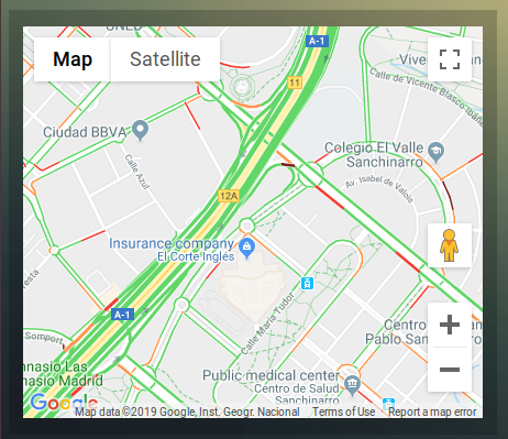
With the ‘maps’ block you can display map from Google Maps, with optionally:
Traffic information
Route to a certain destination.
First get a Google Maps API key: Getting a Google Maps API key
Adding the GM to the dashboard:
config['gm_api'] = 'xxxxxxxxxxxxxx'; // The API key you received from Google

blocks['mymap'] =  {
  type: 'map',
  latitude: 40.4989948,
  longitude: -3.6610076
}
and used in:
columns[3] = {}
columns[3]['blocks'] = ['mymap']
Block parameters
The Google Maps module uses the following block parameters:
Parameter |
Description |
|---|---|
width |
Width of the Google Maps block compared to the full screen, not the column. Full screen width is 12. Meaning width of 6 will give a width of 50% of the screen size. |
height |
The height of the block in pixels |
aspectratio |
The height of the block compared to the width. (default: 0.6) Only applicable if |
latitude |
Latitude |
longitude |
Longitude |
destlatitude |
Latitude of the destination |
destlongitude |
Longitude of the destination |
positionidx |
Domoticz text device number containing the marker coordinates. Text device should be formatted like: “52.321;6.3” |
destidx |
Domoticz text device number containing the destination coordinates. Text device should be formatted like: “52.321;6.3” |
zoom |
Zoom level (default |
showmarker |
true: Show marker on the map (=default)false: Don’t show the marker |
showtraffic |
true: Show actual traffic (=default)false: Don’t show traffic info |
showUI |
true: Shows the default Google Maps UIfalse: Hides the default Google Maps UI (=default) |
showrouteinfo |
true: Show route distance and travel time (=default)false: Hide route info |
showrefresh |
true: Show refresh button in upper right corner (=default)false: Hide refresh button |
Config settings
The Google Maps module uses the following config settings:
Setting |
Description |
|---|---|
gm_api |
The API key you received from Google |
Usage
Getting a Google Maps API key
Obtain your Google Maps API key from:
https://developers.google.com/maps/documentation/javascript/get-api-key
Press Get Started
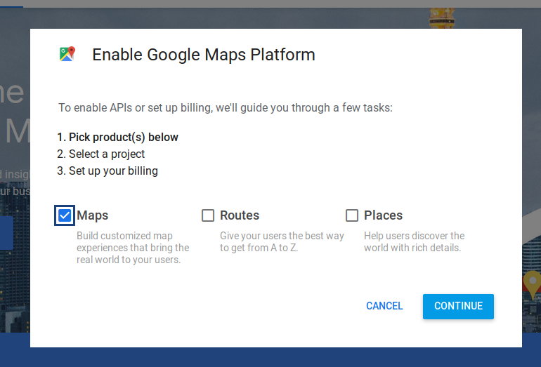
Choose Maps, and press Continue
Follow the instructions
If you would like to be able to display routes, then you have to enable the Directions API as well.
You have to activate billing.
Using Google Maps API costs money. However, you get a monthly credit of $200 for free (June 2023).
If you have a low refresh block parameter, and show multiple maps simultaneously, you may run out of your monthly credit quite quickly.
So, especially in the beginning, pay attention to your API usage via the Google dashboard.
To prevent unnecessary cost, I would recommend to set some quotas in the Google Maps dashboard. For instance, set a limit for the Maps javascript API as well as the Directions API to 500 requests per day. This will limit the cost to max $3.50 + $2.50 = $6.00 per day, meaning you will not reach the $200 monthly credit.
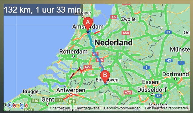
Show a route to a destination
Example of a block to show a route:
blocks['route'] = {
  type: 'map',
  latitude: 52.377956,
  longitude: 4.897070,
  destlatitude: 51.4176337,
  destlongitude: 5.4060209,
}
Dynamic coordinates
For both the marker position as well as the destination position a Domoticz text device can be used to set it’s position. The text device should contain the cooridinates in the following format “latitude;longitude”, like “52.378;4.897” for Amsterdam:
blocks['dynroute'] = {
  type: 'map',
  positionidx: 23, //Domoticz device idx for the marker position
  destidx: 24, //Domoticz device idx for the destination postion
}